Saturday, May 12, 2012
Monday, April 16, 2012
Fritz The Cat - Sailing Colombia to Panama
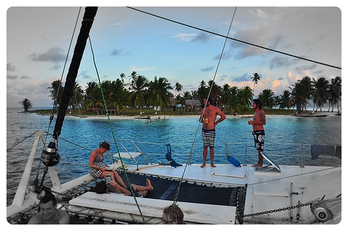
The captain had informed us that the usual place he pulled into was now charging $100 to get our passports stamped so he had organised to meet a guy who works in the immigration department who lives on one of the islands to meet us and stamp our passports. It all worked out fine and so we headed into the mainland. Here a Kuna boat met us and ferried us up a remote river. On the way the captain realised he had left his mobile on the boat and quickly jumped off onto a passing boat and headed back out, leaving us with no idea what we were doing. We thought this may be his quick getaway. Anyway the boat pulled into a little community where a number of 4x4s were waiting to drive us to Panama City.
Wednesday, April 11, 2012
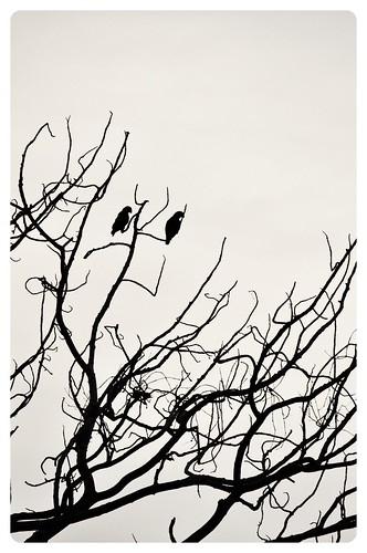
Tayrona National Park - Colombia

There are a few places that you can camp inside the park, the best being Cabo San Juan. It is the furthest to get to but the beaches there are sheltered so they allow you to swim. The beaches on the way in are guarded to stop people swimming as hundreds of people have drowned due to strong currents (maybe more like weak swimmers). We hired a tent for $25, not real cheap but we didn't realise that it was a few days before Easter, the only time of the year the park is busy with Colombians coming in swarms. After 2 days of swimming and chilaxing we headed back to Santa Marta, then up into the mountains nearby to a place called Minca to swim in the rivers, check out some wildlife including Toucans and Macaws. The town sits on the edge of a mountain range called the Sierra Nevada which has the highest coastal mountain range in the world at 5700m only 42km from the coast. It has only been in the last 7 years that it has been safe to travel to this region as it was a strong hold for Guerillas and Narco Trafficas.Tayrona National Park is on the northern coast of Colombia, full of dense jungle, big granite boulders, and crystal clear white Caribbean beaches. We made our way here by flying from Cuzsco to Lima, Lima to Quito, Quito to Medellin. We didn't really love Medellin like most people do, it does sit in a beautiful valley with big green mountains surrounding it but the city was nothing special, maybe we just didnt see what Medellin has to offer. From here we travelled by bus to Santa Marta on the Caribbean coast, and then to Taganga. Taganga is a small fishing village which recently has seen a massive influx of tourists, but the town can't cope with this and the beaches and town is littered with trash, such a shame. We got out and went back to Santa Marta and stayed at this cool hostel called Brisa Loca before leaving our packs there and heading to Tayrona National Park.
After recovering from a bout of food poisoning I gained from eating at probably the most expensive restaurant we had paid during the trip so far, a sign that we should stick to the fresh inexpensive street food, we headed to Cartagena to hang out with thousands of police and security officers (Obama was coming to town along with his Americas President friends).
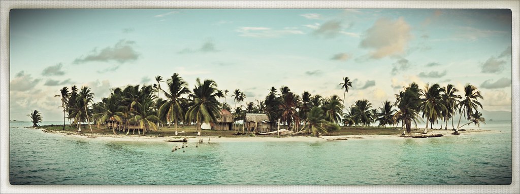
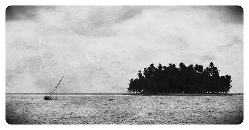
The colonial section of Cartagena is amazing! Surrounded by thick defence stone walls built by the Spanish in 1533, the buildings have all been renovated and turned into a classy neighbourhood with fine restaurants, bars, cafes and shops and is a nice place to just wander the streets. While in Cartagena I decided to head to Panama on one of the many sailing boats that do the voyage from Cartagena to Panama and stopping in the Caribbean San Blas Islands.
I had heard some good reviews about a boat called Fritz The Cat, a big catamaran that sleeps up to 20 people and the boat was due to leave in a few days time. After a couple of days I finally managed to meet the captain, an Austrian guy who has been sailing the route for the last 10 years. I said to him I want to join your boat leaving on Thursday, Fritz replied Super, give me you passport and some dough and I'll see you at 11am. So I handed over my passport and $500 and off he went... It all worked out fine and after loading up with some booze I headed to the boat, met the 15 others and off we sailed.
Saturday, March 24, 2012
The Inca Trail Trek to Machu Picchu

Waking up at 4 in the morning is an easy thing to do when you know what you are going to see today. After waiting in a ridiculous line until 530 with numerous other groups before finally being let through the gates and quickly racing the last section of the Inca trail to the Sun Gate to watch the first rays of light hit the ancient lost city of the Incas, Machu Picchu, is something everyone's should and probably will do in their lives.
The Inca Trail hike is a 4 day walk along one of the hundreds of trails that the Incas used stretching from Ecuador, through Peru, Bolivia, and Chile. The 43km long hike starts in the Sacred Valley by crossing the Urubamba River and heads around into the Cusichaca River before climbing over two mountain passes (the first being the infamous Dead Woman Pass at a lung burning 4200m) before descending into Machu Picchu on the final day.

Day 1 begins with and early pickup from the centre of Cusco and a few hour drive out to KM 82 for the start of the trek. The team of blue SAS porters are already there sorting out the gear of the group into massive bags. There were 14 in our group, 4 hungover Irish (post St Pats Day), 2 Brits complaining about something already, 4 Yanks, 2 Canadians and us. For the 14 in our group there were 2 guides and 19 porters (the Cheskis). Each day 200 permits are issued for the hike and because you have to do the hike with a tour company there is another 200 guides and porters. The first day was pretty easy along the valley (some bogan Aussies are even wearing thongs) past the first of many Inca sites before climbing the bottom section of Dead Woman Pass to our camp site. On the way we stopped for lunch where the Chesky's had already set up a dinning tent and cooked a gourmet meal of quinoa soup, chicken curry, steamed veggies with white sauce, salad and local corn with goats cheese! Immediately I realised Ally will never go hiking with me again after our 3 days of tuna on crackers Patagonia trekking diets... And dinner was the same just with different local dishes and and an entree of popcorn. Arriving at the campsite the tents were already set up and we were greeted with warm water to wash in. "SAS is the best".
Day 2 began with a very early wake up with hot tea passed through the fly of our tents, followed by a hot breakfast, coffee, and what seamed like unlimited milo (I did try to eat the whole supplies of milo but I think there must have been a porter designated to just carrying it). It was a slow and long way up to Dead Woman Pass, and the air gets thin at the top. It is along this stretch that we walk along the remains of the original inca trail. Unlike society these days the Incas built things to last for eternity and the cobble stone path is a testament to this. Our group did well and the SAS guides were quick to whip out some oxygen and meds when it was required. The Aussie bogan girls previously mentioned in the other group managed a smoke at the pass though. I was really quite surprised with the size of the mountains in this area, the snow capped peaks sit well above 5000m, and the valleys are deep and a long way down. From Dead Woman Pass it is a steep drop down into the valley to the lunch site and a serving of ceviche, a south American dish of raw freshly caught trout marinated in lime juice. We still had another pass to conquer before descending into camp and more piles of milo.

Day 3 was the most spectacular day apart from Machu Picchu with amazing sections of trail that just hang to the sides of the mountains. After a night of rain we woke to perfect clear skies and great views of the surrounding mountains. The final camp is only a short distance to the lost city.
We however didn't make it to the sun gate before sunrise due to the lines to get through the gates from the last camp, they don't open until 530am. Even though I group was up at 4am others apparently woke at 2am to get in line! Everyone has seen picture postcards of Machu Picchu but to go there and walk amongst the ruins, after trekking for days through amazing diverse landscapes is a must do. Otherwise you can catch a train and a bus and be there in a day....
Thursday, March 15, 2012
Copacabana and Lake Titicaca - Bolivia

Lake Titicaca is the highest navigable lake in the world at 3800m above sea level and forms part of the border between Bolivia and Peru. From Copacabana a town on the Bolivian shore you can catch a boat out to the Isla del Sol (Island of the Sun), a very varse but beautiful island which is believed to be the birth place of the Incas. You can stay overnight on the island or do a day trip and hike the length as what we did. The boat too and from the island is bloody slow and painful.
We stayed at a beautiful hotel that sits just above Copacabana called Hotel La Cúpula for $20 a night!
Saturday, March 10, 2012
Death Road - La Paz Bolivia

We headed out to ride the infamous 'Death Road' with a tour group of 6. The top of the road is at about 4500m and finishes at 1200m. When we got to the top it was snowing and the road was icy so we started a little bit down the road. On the way down we stopped while the guide helped to pull a ute out of a ditch after slipping off the road. Great start.
The top part of the road is sealed and we all just cruised down together.
The next section is the Death road, which until about 6 years ago was the main (dirt) road used by everything from trucks, and buses. It was regarded as the most dangerous road in the world. Now there is a new road so it's pretty safe, unless you miss a corner and drop off the cliffs...
The guide let us push the pace which made it fun as there was another guy who was pretty good. The guide we found out later is #2 downhill racer in Bolivia. There were a few times I would take a corner and be looking down a couple hundred metre drop about a foot to my left..
By the time you reach the bottom it was hot and tropical. Such a difference to the top.
On the drive back up the main road we passed another crash between one of the tour vans and another car, all we're fine.
Tuesday, March 6, 2012
4x4 Desert Tour - San Pedro to Uyuni, Bolivia

We boarded a mini bus and headed back out of San Pedro de Atacama to the border of Chile and Bolivia. The border crossing sits at 4400m up on the dry desert plains, and underneath the perfectly shaped Lincancabur Volcano. It is here that we meet our guide, and his 4x4. After reading so many horror stories about both the 4x4s and the guides, I quickly checked out the vehicle. 4 wheels, yep that will do, and off we went in our luxurious Lexus, while the others clambered into their shity Toyotas... There were 6 of us in our group plus the driver, lucky for us there's a Chilean born girl that's been living in Miami most of her life, designated translator!

The first day we travelled almost in convoy through an amazing part of the world, with Volcanoes either side, and red dusty desert inbetween. We stopped at different spots including, Laguna Verde (Green Lake), Laguna Blanco (White Lake), another Laguna with hot springs, Sol de Mañana a geyser site which at almost 5000m was both freezing and lacking vital oxygen, and Laguna Colorado. Laguna Colorado was stunning! It's rich red colour due to algae attracts thousands of flamingoes, and along the shore were herds of llamas with bows in their hair (to celebrate llamas birthday) chewing the grass and posing for photos.
The night was spent out at a remote hostel in the middle of the desert at 4400m. It was pretty basic, beds, no showers, but was comfortable we were expecting worse. Food was alright and they even gave us a bottle of wine.


The following day we continues onwards towards Uyuni. More lagunas, more snow capped volcanoes, and more red dusty plains. We stopped at two spectacular rocky outcrops, before heading the the train museum, where trains go to die on the out skirts of Uyuni.

The Japanese guys that we were travelling with had been talking about heading out to the nearby Salar de Uyuni at night which is the worlds largest salt flat, 10000 square kilometres (Sydney is 1580 square kilometres), and contains 50-70% of the worlds lithium reserves [1]. They organised another 4x4 guy to take us out. During the wet season parts of the salt flat are covered by a few centimetres of water. By heading out into the middle of the salt flat at night, with a clear sky, you can get an almost perfect 360 degree reflection of the stars which is suppose to feel like you are floating in space. The night wasn't perfect for this, pretty full moon and cloudy, but it was one of the highlights of our trip! We were driven out first to the edge of the salt flats, before driving out to the centre. Near the edge was the deepest section of the lake, which apparently moves around depending on the wind. Driving out onto the lake was a weird experience, not sure whether we were going to sink, the salt flats actually turned out be rather hard, not boggy at all. Out in the middle where it was drier, we pulled out some chairs, cracked a bottle of wine and sat with no other cars or people around and watched an amazing lightning storm with bolts striking the otherside of the lake. Amazing!
The last morning of the tour we headed back out to the salt flats nice and early to watch the sunrise. This again was amazing, but this time slightly ruined by the hordes of other loud and annoying 4x4 tour groups.
Subscribe to:
Comments (Atom)