Saturday, May 12, 2012
Monday, April 16, 2012
Fritz The Cat - Sailing Colombia to Panama
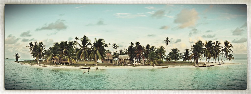
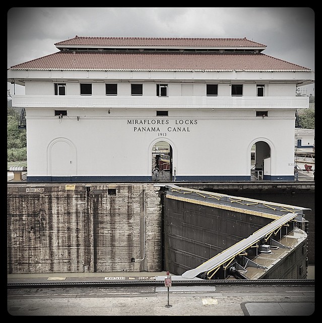
The captain had informed us that the usual place he pulled into was now charging $100 to get our passports stamped so he had organised to meet a guy who works in the immigration department who lives on one of the islands to meet us and stamp our passports. It all worked out fine and so we headed into the mainland. Here a Kuna boat met us and ferried us up a remote river. On the way the captain realised he had left his mobile on the boat and quickly jumped off onto a passing boat and headed back out, leaving us with no idea what we were doing. We thought this may be his quick getaway. Anyway the boat pulled into a little community where a number of 4x4s were waiting to drive us to Panama City.
Wednesday, April 11, 2012
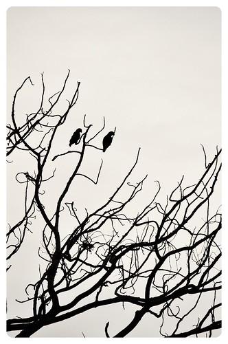
Tayrona National Park - Colombia

There are a few places that you can camp inside the park, the best being Cabo San Juan. It is the furthest to get to but the beaches there are sheltered so they allow you to swim. The beaches on the way in are guarded to stop people swimming as hundreds of people have drowned due to strong currents (maybe more like weak swimmers). We hired a tent for $25, not real cheap but we didn't realise that it was a few days before Easter, the only time of the year the park is busy with Colombians coming in swarms. After 2 days of swimming and chilaxing we headed back to Santa Marta, then up into the mountains nearby to a place called Minca to swim in the rivers, check out some wildlife including Toucans and Macaws. The town sits on the edge of a mountain range called the Sierra Nevada which has the highest coastal mountain range in the world at 5700m only 42km from the coast. It has only been in the last 7 years that it has been safe to travel to this region as it was a strong hold for Guerillas and Narco Trafficas.Tayrona National Park is on the northern coast of Colombia, full of dense jungle, big granite boulders, and crystal clear white Caribbean beaches. We made our way here by flying from Cuzsco to Lima, Lima to Quito, Quito to Medellin. We didn't really love Medellin like most people do, it does sit in a beautiful valley with big green mountains surrounding it but the city was nothing special, maybe we just didnt see what Medellin has to offer. From here we travelled by bus to Santa Marta on the Caribbean coast, and then to Taganga. Taganga is a small fishing village which recently has seen a massive influx of tourists, but the town can't cope with this and the beaches and town is littered with trash, such a shame. We got out and went back to Santa Marta and stayed at this cool hostel called Brisa Loca before leaving our packs there and heading to Tayrona National Park.
After recovering from a bout of food poisoning I gained from eating at probably the most expensive restaurant we had paid during the trip so far, a sign that we should stick to the fresh inexpensive street food, we headed to Cartagena to hang out with thousands of police and security officers (Obama was coming to town along with his Americas President friends).
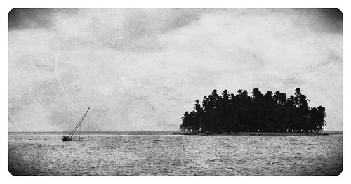
The colonial section of Cartagena is amazing! Surrounded by thick defence stone walls built by the Spanish in 1533, the buildings have all been renovated and turned into a classy neighbourhood with fine restaurants, bars, cafes and shops and is a nice place to just wander the streets. While in Cartagena I decided to head to Panama on one of the many sailing boats that do the voyage from Cartagena to Panama and stopping in the Caribbean San Blas Islands.
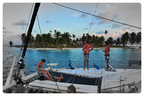
I had heard some good reviews about a boat called Fritz The Cat, a big catamaran that sleeps up to 20 people and the boat was due to leave in a few days time. After a couple of days I finally managed to meet the captain, an Austrian guy who has been sailing the route for the last 10 years. I said to him I want to join your boat leaving on Thursday, Fritz replied Super, give me you passport and some dough and I'll see you at 11am. So I handed over my passport and $500 and off he went... It all worked out fine and after loading up with some booze I headed to the boat, met the 15 others and off we sailed.
Saturday, March 24, 2012
The Inca Trail Trek to Machu Picchu

Waking up at 4 in the morning is an easy thing to do when you know what you are going to see today. After waiting in a ridiculous line until 530 with numerous other groups before finally being let through the gates and quickly racing the last section of the Inca trail to the Sun Gate to watch the first rays of light hit the ancient lost city of the Incas, Machu Picchu, is something everyone's should and probably will do in their lives.
The Inca Trail hike is a 4 day walk along one of the hundreds of trails that the Incas used stretching from Ecuador, through Peru, Bolivia, and Chile. The 43km long hike starts in the Sacred Valley by crossing the Urubamba River and heads around into the Cusichaca River before climbing over two mountain passes (the first being the infamous Dead Woman Pass at a lung burning 4200m) before descending into Machu Picchu on the final day.

Day 1 begins with and early pickup from the centre of Cusco and a few hour drive out to KM 82 for the start of the trek. The team of blue SAS porters are already there sorting out the gear of the group into massive bags. There were 14 in our group, 4 hungover Irish (post St Pats Day), 2 Brits complaining about something already, 4 Yanks, 2 Canadians and us. For the 14 in our group there were 2 guides and 19 porters (the Cheskis). Each day 200 permits are issued for the hike and because you have to do the hike with a tour company there is another 200 guides and porters. The first day was pretty easy along the valley (some bogan Aussies are even wearing thongs) past the first of many Inca sites before climbing the bottom section of Dead Woman Pass to our camp site. On the way we stopped for lunch where the Chesky's had already set up a dinning tent and cooked a gourmet meal of quinoa soup, chicken curry, steamed veggies with white sauce, salad and local corn with goats cheese! Immediately I realised Ally will never go hiking with me again after our 3 days of tuna on crackers Patagonia trekking diets... And dinner was the same just with different local dishes and and an entree of popcorn. Arriving at the campsite the tents were already set up and we were greeted with warm water to wash in. "SAS is the best".
Day 2 began with a very early wake up with hot tea passed through the fly of our tents, followed by a hot breakfast, coffee, and what seamed like unlimited milo (I did try to eat the whole supplies of milo but I think there must have been a porter designated to just carrying it). It was a slow and long way up to Dead Woman Pass, and the air gets thin at the top. It is along this stretch that we walk along the remains of the original inca trail. Unlike society these days the Incas built things to last for eternity and the cobble stone path is a testament to this. Our group did well and the SAS guides were quick to whip out some oxygen and meds when it was required. The Aussie bogan girls previously mentioned in the other group managed a smoke at the pass though. I was really quite surprised with the size of the mountains in this area, the snow capped peaks sit well above 5000m, and the valleys are deep and a long way down. From Dead Woman Pass it is a steep drop down into the valley to the lunch site and a serving of ceviche, a south American dish of raw freshly caught trout marinated in lime juice. We still had another pass to conquer before descending into camp and more piles of milo.

Day 3 was the most spectacular day apart from Machu Picchu with amazing sections of trail that just hang to the sides of the mountains. After a night of rain we woke to perfect clear skies and great views of the surrounding mountains. The final camp is only a short distance to the lost city.
We however didn't make it to the sun gate before sunrise due to the lines to get through the gates from the last camp, they don't open until 530am. Even though I group was up at 4am others apparently woke at 2am to get in line! Everyone has seen picture postcards of Machu Picchu but to go there and walk amongst the ruins, after trekking for days through amazing diverse landscapes is a must do. Otherwise you can catch a train and a bus and be there in a day....
Thursday, March 15, 2012
Copacabana and Lake Titicaca - Bolivia

Lake Titicaca is the highest navigable lake in the world at 3800m above sea level and forms part of the border between Bolivia and Peru. From Copacabana a town on the Bolivian shore you can catch a boat out to the Isla del Sol (Island of the Sun), a very varse but beautiful island which is believed to be the birth place of the Incas. You can stay overnight on the island or do a day trip and hike the length as what we did. The boat too and from the island is bloody slow and painful.
We stayed at a beautiful hotel that sits just above Copacabana called Hotel La Cúpula for $20 a night!
Saturday, March 10, 2012
Death Road - La Paz Bolivia

We headed out to ride the infamous 'Death Road' with a tour group of 6. The top of the road is at about 4500m and finishes at 1200m. When we got to the top it was snowing and the road was icy so we started a little bit down the road. On the way down we stopped while the guide helped to pull a ute out of a ditch after slipping off the road. Great start.
The top part of the road is sealed and we all just cruised down together.
The next section is the Death road, which until about 6 years ago was the main (dirt) road used by everything from trucks, and buses. It was regarded as the most dangerous road in the world. Now there is a new road so it's pretty safe, unless you miss a corner and drop off the cliffs...
The guide let us push the pace which made it fun as there was another guy who was pretty good. The guide we found out later is #2 downhill racer in Bolivia. There were a few times I would take a corner and be looking down a couple hundred metre drop about a foot to my left..
By the time you reach the bottom it was hot and tropical. Such a difference to the top.
On the drive back up the main road we passed another crash between one of the tour vans and another car, all we're fine.
Tuesday, March 6, 2012
4x4 Desert Tour - San Pedro to Uyuni, Bolivia

We boarded a mini bus and headed back out of San Pedro de Atacama to the border of Chile and Bolivia. The border crossing sits at 4400m up on the dry desert plains, and underneath the perfectly shaped Lincancabur Volcano. It is here that we meet our guide, and his 4x4. After reading so many horror stories about both the 4x4s and the guides, I quickly checked out the vehicle. 4 wheels, yep that will do, and off we went in our luxurious Lexus, while the others clambered into their shity Toyotas... There were 6 of us in our group plus the driver, lucky for us there's a Chilean born girl that's been living in Miami most of her life, designated translator!

The first day we travelled almost in convoy through an amazing part of the world, with Volcanoes either side, and red dusty desert inbetween. We stopped at different spots including, Laguna Verde (Green Lake), Laguna Blanco (White Lake), another Laguna with hot springs, Sol de Mañana a geyser site which at almost 5000m was both freezing and lacking vital oxygen, and Laguna Colorado. Laguna Colorado was stunning! It's rich red colour due to algae attracts thousands of flamingoes, and along the shore were herds of llamas with bows in their hair (to celebrate llamas birthday) chewing the grass and posing for photos.
The night was spent out at a remote hostel in the middle of the desert at 4400m. It was pretty basic, beds, no showers, but was comfortable we were expecting worse. Food was alright and they even gave us a bottle of wine.


The following day we continues onwards towards Uyuni. More lagunas, more snow capped volcanoes, and more red dusty plains. We stopped at two spectacular rocky outcrops, before heading the the train museum, where trains go to die on the out skirts of Uyuni.

The Japanese guys that we were travelling with had been talking about heading out to the nearby Salar de Uyuni at night which is the worlds largest salt flat, 10000 square kilometres (Sydney is 1580 square kilometres), and contains 50-70% of the worlds lithium reserves [1]. They organised another 4x4 guy to take us out. During the wet season parts of the salt flat are covered by a few centimetres of water. By heading out into the middle of the salt flat at night, with a clear sky, you can get an almost perfect 360 degree reflection of the stars which is suppose to feel like you are floating in space. The night wasn't perfect for this, pretty full moon and cloudy, but it was one of the highlights of our trip! We were driven out first to the edge of the salt flats, before driving out to the centre. Near the edge was the deepest section of the lake, which apparently moves around depending on the wind. Driving out onto the lake was a weird experience, not sure whether we were going to sink, the salt flats actually turned out be rather hard, not boggy at all. Out in the middle where it was drier, we pulled out some chairs, cracked a bottle of wine and sat with no other cars or people around and watched an amazing lightning storm with bolts striking the otherside of the lake. Amazing!
The last morning of the tour we headed back out to the salt flats nice and early to watch the sunrise. This again was amazing, but this time slightly ruined by the hordes of other loud and annoying 4x4 tour groups.
Thursday, March 1, 2012
San Pedro de Atacama - Chile

The bus from Salta to San Pedro is quite amazing. The trip takes you north through Argentine farmland before heading east up through an amazing valley, with heaps of switchbacks to rival a French Alps climb, until finally climbing up onto a Andes plateau at around 4200m. By now the air in the bus was getting thin and you could really feel the altitude. From here the road crosses the dry desert climate, with Volcanic peaks off in the distance on either side, and also crossing a salt flat before crossing the border into Chile, and descending into San Pedro de Atacama.

The town itself still sits at 2400m and is no more than a dust bowl, with a few streets full of decent restaurants and tourist outlets. We spent a day relaxing at the hostel trying to acclimatise to the altitude, and also searching the dozen outlets offering 4x4 tours through the desert into Bolivia. After reading heaps of horror stories of cars braking down, crashing, etc, etc, we booked with Estrella del Sur a Bolivian family run company that seemed to have some good reviews.
The following day we jumped on another tour up to El Tatio geysers, the highest geysers in the world at 4300m and supposed to be the highlight of the Atacama. The tour leaves town at 4am to make sure you arrive at sunrise when the geysers are most active. The scenery is pretty amazing with Volcanoes surrounding the site, but the geysers themselves were a bit of a disappointment. It may have just been the day we went but they weren't very active, only bubbling up a metre or so, and there wasn't the colours that were expected. Go to New Zealand instead.. The highlight was probably the herds of Vicuña that are a smaller relative to the llamas, and are now a protected species, and also the Vizcacha, a member of the rodent family that live in nearby rocky area.

On the Saturday before we left town, we watched the competitors who were racing in the Atacama Crossing, head off on foot to the first camp before starting the 7 day ultra marathon race the following morning. www.4deserts.com/atacamacrossing
Tuesday, February 28, 2012
Salta & Cafayate - North West Region of Argentina

Salta is a city in the north west region of Argentina, getting there required another long 20hr bus ride from Mendoza. The city of 500000 sits just west of the Snow capped Andes mountain range, in a valley with San Bernardo Hill looking over the city to the east (which like any town in south America that has a cable car to the top). It's quite a nice city but not too much to do apart from check out shops, churches and restaurants. We only spent one night here before heading 4hrs south to the town of Cafayate.

We didn't really know what to expect on the drive to Cafayate but it was spectacular and for once we scored the front row top seats. The drive takes you through Quebrada del Rio de las Conchas (Canyon of the river of shells) and Calchaquíes Valley. The valleys are full of massive cacti, and red dusty eroded hills and rock formations. It looked like we had driven to mars. The valley near by apparently features in Star Wars - The Empire Strikes Back. The river running through the valley must have been experiencing a large amount of rain fall further up on the Andes range as it was pumping, and had eroded away part of the road in a few sections.
The town of Cafayate is regarded as the Tuscany of Argentina, surrounded by winyards, and large rocky dry mountains covered in cacti. The town is small and dusty, but with plenty of restaurants, shops and a nice plaza. We stayed at this pretty nice hostel which had a cool out door area to sit around in, covered by grape vines. We tried to hire a car as it seamed like the easiest way to explore the region but found out we should have done this back in Salta..

The following day we hire some bikes and caught the bus back out the the Valleys we had driven through the day before. The bus dropped us off about 50km out of town at this big dry canyon called Devil's Throat. The ride from here just headed back along the main road which was a fairly easy ride with only a few hills, however we did climb from 1300m to 1800m to where the town sits. The ride was amazing and by the end my neck hurt more than my legs from continually looking around at the different rock formations and eroded landscape. The last part of the ride was pretty tough, as by now it was bloody hot, with no shade, and long straight and boring.
The next day we headed out on foot along this dry, boring road to Rio Colorado. From here you head up the river, rock hopping and wading through the river as there isn't really a track. We got caught by a group being lead by a guide at one stage and tagged onto the back. The walk brings you up to a 10m waterfall and swimming holes. Really nice.

That evening we ate out near the plaza. We were joined by a local donkey who really wanted to share my steak... He got a few chips but still wasn't happy... I don't blame him it was delicious.
Saturday, February 25, 2012
Mendoza - Argentine wine district

With the highest part of the Andes Mountain range to the West of the city, Aconcagua (highest mountain in the Western hemisphere at 6960m and one of the 7 summits), Mendoza is Argentina's wine district, With Malbec being the grape of choice. Wine is everything to this city, which is surrounded for hundreds of kilometres by vineyards. Even the cities fountains spurt delicious red Malbec, a cool trick that Baby Jesus never managed to master..

It was the start of the wine harvest festival, which meant wine tasting throughout the cities streets. The region has a very dry climate receiving only 15cm of rain per year. Our first outing required us taking shelter beneath a door way while the city streets turned into rivers during a heavy storm.. I think we may have bought the Sydney rain with us. We also did a self guided cycle wine tour through the nearby town of Maipu. Great wine, but the scenery was a bit of a let down. Go to Margaret river instead. Some of the other vineyard areas a little closer to the mountains I think would be better.
Sunday, February 19, 2012
Bariloche - The Argentine Lakes District
Bariloche is a swiss inspired town, beautiful wooden lodges, ski resorts in winter, bike riding around lakes, and mountain hiking in summer, littered with chocolate shops and good restaurants. It's a place the Argentines like to spends their vacations. You can even get your photo with a Saint Bernard "Beethoven movie dog" at every scenic point, or tourist landmark...

The best part of Bariloche is the surrounding Nahuel Huapi National Park. Here we did an overnight trek up into the Arroyo Goye valley to Refugio Italia on Laguna Negra. The walk followed the river upstream until hitting this massive waterfall which is fed by Laguna Negra above. We really didn't know what to expect on this walk, we just new there was a Refugio you could stay at overnight, but the walk was stunning. The Refugio was smallish compared to the ones in Torres del Paine, but slept about 30 people comfortably. We had bought food to cook, but you really didn't need to bring anything as a couple of Argentines cooked a gourmet meal for those who paid for it. We spent the night cozy and warm between the wood oven, and bar heater (behind the resident cat) and drank a bottle of delicious Malbec we bought at the Refugio for ~$12 AUD. Bliss.

Before catching an afternoon bus to Mendoza, we headed out to the Llao Llao Peninsula and hired some bikes to ride the circuit, which weaves through huge pine forests, beaches and mountains, very scenic, even Beethoven seemed to be enjoying the views. Nice to be riding a bike again, I quite enjoyed pushing Ally up the Hills.
The lakes district is a place that we will have to return to, especially the Chilean side, could happily spend a month or two here.
Sunday, February 12, 2012
El Chaltén, Argentina - Patagonia

We travelled further north staying in El Chaltén, Argentina, which is a little town at the base of Fitz Roy and Cerro Torre mountain ranges, which are some of the toughest climbs in the world. El Chaltén is the trekking capital of Argentina, situated in the north of Los Glaciares National Park, and all the treks start in town so most can be done in a day.There isn't much in the town itself apart from hostels, and restaurants, but that's not why you travel here.The first day we had some nice weather, but the tops of the peaks were hidden by clouds. We however headed out to trek up to a peak Lomo del Pliegue Tumbado at 1490m which gives a panorama view of the mountain ranges. It was awesome. The walk headed through some farms before climbing through this beautiful forrest, then emerging above the tree line to a clear view of both Fitz Roy (at 3405m) and Cerro Torre(3102m) ranges, and the glacier separating the two. Cerro Torre was still hidden but just before heading back it peeked it's head out. Cerro Torre was claimed to be first climbed in the 1950s, however one of the two climbers, who happened to be the photographer, perished on the descent so there was never any proof. Recently a team of climbers tried to follow the route taken but found it impossible... Sounds like an episode of The Simpsons...The following couple of days the mountains were again hidden. Lucky to have had a superb day!
Friday, February 10, 2012
The 'W' trek in Torres del Paine - Chile
Feb 10 2012, We boarded a bus from town and headed the 3 hrs to and into the national park to Gaurdería Pudeto to catch a boat across to Refugio Paine Grande to start the trek. This area we were advised to skip due to a fire that had started up at Refugio Grey campsite on the 28th of Dec, when a camper wandered off into the bush to go to the toilet, tried to burn his toilet paper, which resulted in probably about 40% of the National park being destroyed! No idea how nobody died because the hundred km strong winds that blow basically all the time would have spread the fire incredibly fast. This section of the walk had only just opened and a few of the campsites were still closed. Somehow Refugio Paine Grande which is a massive hut/hotel, which was in the direct path of the fire survived, and sits in the middle of a black charcoaled valley with a meter of green grass surrounding it! Check out the photos.The first day was freezing, wet, with a massive head wind (Patagonia is always windy), and sleet, but this was only a short 11km day. When we got to the refugio grey, next to glacier grey, we were cold and wet, so walked straight into the refugio and they had spare beds for $30. It was like a five star hotel. But we still had to cook with the camping plebs and felt a little bad, especially when we pulled out and cooked up some chorizo sausages and most of these walkers had been 5 days into the 10day full circuit of Torres del Paine.The next day was beautiful so we made the most of the good weather and did 2 days worth of hiking, 36km. The route took us back through the burnt Forrest passing Refugio Paine Grande and around to Campamento Italiano. This camp was closed, so we left out big packs and headed up the 800m climb into French Valley. Absolutely amazing! The scenery beats cradle mountain. After heading back and picking up our bags we headed around to Refugio Los Cuernos, which sits under the spectacular Cuernos peaks. The camp here was almost full by the time we got there so we got a crap camp site, and got smashed by the wind the next morning. The third day was windy again, wind that when it hits you knocks you over! But it was weirdly warm. We were going to have an easy day to camp Torres but we found out this was shut due to the wind (maybe it was windier than normal?) , so we left our bags at Camp Chileno and did the hike up to The Torres peaks, amazing, and back down to catch the late bus back to town. The photos of the Torres peaks don't really show how massive they are, but the lake at the base is at ~900m and the peaks are upto 2850m! You do the math...
Friday, February 3, 2012
El Calafate - Patagonia & Perito Moreno Glacier
El Calafate - Argentina - Feb 3 2012Flew to El Calafate via BsAs. In stark contrast to Rio de Janerio, El Calafate is a small touristy town situated on Lago Argentino and surrounded by desert farm land, but it is the gate way to Los Glaciares National Park. The town is quite pleasant, similar to an alpine village with great restaurants and heaps of camping shops. We stayed at a hostel and shared a dorm with some other Aussies who are doing a similar trip on the way to working in the UK. We had dinner at La Tablita a steak house and we had a giant parrilladas (mixed grill). The meat is so good. Worth the trip. The following day we boarded a tour bus out to see Perito Moreno Glacier. The glacier is one of the only ones in the world that isn't receding. It's massive! You could fit the whole of BsAs on it. The glacier is fed by the Southern Patagonian Ice Field, which is the 2nd largest extrapolar ice field in the world, and is also the worlds 3rd largest reserve of fresh water. The tour lets you walk around on a series of board walks for a few hours before boarding a boat and navigating around the lake up to the glacier. I got to capture a large section breaking off.
Thursday, February 2, 2012
Rio de Janeiro baby
Jan 30 - Feb 03 2012Rio de JaneiroThe first sights of Rio on the bus travelling through the outer impoverished suburbs, worse than slums seen in south east Asia, paints a grim picture of what is truly one of the most stunning cities in the world. Huge granite mountains, beautiful beaches, and a city that is somehow squeezed in between is an amazing place.Once surviving our first taxi ride with no mugging, or kidnapping, and settling into our studio flat 2 blocks from Copacabana beach, we were ready to explore... This was until my guts decided that the cheese and ham pastry (looked a little white ham) we had on the bus needed urgent evacuation. After a little lying around I decided to have a quick look at the beach. Followed by a brisk walk back to the marvellous view of the toilet. The following day after a pretty settled night, it was raining, but we were able to walk to the nearby beach Ipanema, which is towered over by the granite mountains Pedra Dois Irmãos (Two Brothers Rock). In the afternoon we walked around to Urca to see Sugarloaf, the mountain with the cable car, which stands at the entrance to the harbour and towers over the beaches and city. It was cloudy so decided to save going up for another day.We woke the next day to bright blue skies and quickly decided to give the hike up to Corcovado and the statue of Christ overlooking the city. After a bit of googling I was pretty sure there was a track starting from the neighbourhood directly below the mountain in the suburb of Jardim Botânical. The entrance was through the gardens of this amazing old building, with the only directions being, walk through the garden until you find a ruin in the far back right, the track starts behind it... Not being put of by the numerous security guards wandering through the gardens forest, and checking out some cool caves, we found a guard sitting in a ruin and the start of the track. The track heads up, and up through the rainforest Tijuca National Park, the largest urban forest in the world. After climbing 700m, past walter falls, deadly snakes ( well one), no monkeys, or muggings, and a little rock climbing, you hit the railway line, and road transporting thousands of tourist to the top, so they can take lame photos of themselves mimicking Christ. The view is amazing, that is if you can manage to get to the edge through the crowds. On our final day we caught the metro subway into Santa Teresa followed by another swim, before heading up the cable cars to the summit of Sugarloaf in the evening to watch the sunset over the city. This is a must do!Rio will be a great city for the World Cup Football and the Olympics. They seem to be sorting out their security problems of the last few decades, police everywhere, and we never felt to insecure.
Monday, January 30, 2012
Paraty - Brazil
Paraty is an old colonial town on the coast of brazil. It grew to importance in the 1800s when it became the main shipping port for gold on the way to Portugal. Then once gold became scarce, shipping switched to coffee, but this died off with the abolishment of slavery in the 1880s. Today Paraty is a pretty cobblestone (minor boulders) street town, free of cars, however if would be too rough to drive through anyway. From here you can board boats and explore the surrounding jungle islands,and beautiful beaches.We spent 4 nights here living in a small room just out of the centre, 3 days of which rained! We however enjoyed this town, good street food including these awesome cake trolleys that are wheeled around through the streets. Our neighbour and the guy managing the flat Jorge, was a great host, took us out for drinks ($1.30 cans), and showed us how to Samba which has become popular with the youth. He has moved to Paraty to set up an adventure tour company, after being inspired after travelling for years through NZ and Aus. He is also a adventure racer, having even raced a few Aussie races such as AROC 24hr. Random...On the last day is finally cleared up a little so we got a chance to hop on a tour boat out to some of the beaches around the peninsular.
Thursday, January 26, 2012
Iguazú Falls
We arrive at Puerto Iguazú at 10am 24th Jan, only 2.5 hrs late.. Making it a nice almost 20hr trip, but the bus was comfortable, next time we will sit a little further away from the toilets..Iguazú Falls are situated in the north of Argentina and the river is the boarder between Argentina and Brazil, with Paraguay not too far away. This enables viewing the falls from both countries, however we only viewed it from the Argentinean side. The falls are a world heritage site and are made up of 275 different falls across 2.3km.The afternoon after arriving we caught a bus to check out the upper falls which included the Devil's Throat at the very head, where almost a 500m wide river falls away into a gorge 50m wide, dropping 70 m. No need to trek for days through the jungle to see this, you just board the mini train at the entrance and then head out along some quality board walks over the top of the river. When you walk up to the top viewing platform which sits right on the edge, it is a truly breath taking moment as you feel as though the world is collapsing in on itself. Worth the trip!We then wandered back through the hoards of tourists, all surprisingly Argentinean and Brazilians, not many Aussies, Japs, or Yanks.The following day we headed back out in the morning to see the falls from the bottom, the same just this time looking up, and you get wetter. Before leaving we did the short walk back to the main centre along a path through the jungle, seeing heaps of parakeets, but unfortunately we didn't see any cute little jaguar or puma cubs, caiman, or monkeys, which all can be found... Although some rarer than others.
Tuesday, January 24, 2012
Buenos Aires
Arrived in BsAs on Wednesday 18th January. We booked a room through Airbnb in the southern part of the city in Barracus which is about 8km from the centre. We have been staying in a 2 bedroom flat with Pomi the father of the owner of the flat. Pomi speaks no English and we speak about the same Spanish. He likes to talk and we like to nod and say sí... It's the perfect relationship...
The first day we headed out to see some of the sights, first walked to the near by neighbourhood of La Boca. La Boca is a very poor part of town next to the old docks where the Italiano's immigrated to. The small touristy part of town is brightly painted which is a bit of a gimme to attract hoards of buses.
Boca Juniors Fútbol team resides nearby, made famous by Diego Maradona.
From here we survived our first local bus experience. The buses hammer though the narrow streets, overtaking cars and racing each other. It is an extremely efficient way to travel, and there are about a thousand buses and hour. NSW state government could learn a thing or two.
The architecture throughout the city is amazing. Rivalling grand European cities. And the food is both cheap and great.
Another outing we headed to Recoleta cemetery. The cemetery for the rich and famous created in 1822. Mausoleums cost the families thousands of $$ each year and are an architectural free for all. The most famous tomb being Eva (Evita) Perón.
Subscribe to:
Posts (Atom)